Listen to The Rock Music

“Kareem, how did we learn this stuff about the Earth’s insides? I mean, clouds and winds hundreds of miles down?”

“Fair question, Eddie. Jules Verne’s Voyage to The Center of The Earth couldn’t happen, because hollow volcanic tubes don’t go near far enough down. Drilling’s not useful for exploring the mantle — we’ve only gotten about six miles through the seafloor crust and that’s still probably a dozen miles up from where the mantle starts. Forget what you’ve seen in the comics or a movie, we won’t in our lifetimes have a sub‑like vehicle that can melt through rock, withstand million‑atmosphere pressures and swim through superheated lava. So what we do is oscillate, triangulate and calulate.”

“I’ll bite. Oscillate? Triangulate?”

“How we do earthquake chasing, Sy. For thousands of years, humanity experienced a quake as a local jolt. It wasn’t until the 1850s that we realized each quake incident has multiple components: a sudden rupture somewhere, the resulting shock that travels through the Earth to other locations, and maybe aftershocks from follow‑on ruptures. The shock is a whole train of waves. We used to record them on those big cylindrical seismograph drums with oscillating pens, but most stations have gone digital since the early 90s. More accurate data, easier to handle but less picturesque.”

“True. The TV weather guys love pics of the big cylinder with all the wiggly lines. How about the triangulations?”

“Suppose you feel an earthquake shock. How do you find out where the rupture occurred and how big it was?”

“Hard to do from one location. A really big one far away would give you the same blip as a small one close by. And you probably wouldn’t know how deep it was or what direction it came from. I guess you’d need to compare notes with some far‑away observers. The one closest to the rupture would have received the strongest signal.”

“Yeah, Sy, and if everybody kept track of when they felt the jolt then you could draw a map with the different times and that’d zero in on it. Uhh … three places and you’ve got it.”

The IRIS Global Seismic Network as of 2021.

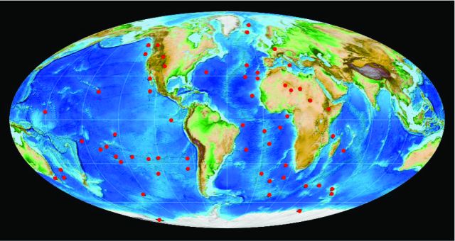
“Three points makes a triangle, Eddie, you’ve just described triangulation. It’s a general principle — the more points of view you have to work with, the better the image. Seismic tomography is all about merging well‑characterized data from lots of stations. That’s why we built an international Global Seismic Network, 152 identically‑equipped stations. Here’s a map.”

“How ’bout that, Sy? Lotsa triangles, all over the world.”

“Reminds me of Feynman’s insight that an electron doesn’t take just one path from A to B, it takes all possible paths. Earthquake shocks must go around the Earth and through the Earth, so each of those stations could hear multiple wave trains from a strong‑enough earthquake. These days it’s all digital, I suppose, and tied together with high‑precision time‑ticks. Kareem, they must be able to localize within a millimeter.”

“Not really, Sy. There’s a complication the early seismologists discovered even with primitive timing and recording equipment. The waves don’t all travel at the same speed. Depending on what’s in the way some of them even stop.”

“Wait, these shocks are basically sound waves. Does sound go fast or slow or stop depending on where it is in the Earth?”

“Sonic physics, Sy. The stiffer the material the faster sound travels. About 1½ kilometer/second in water, 3 in stone and 6 in metals but those numbers vary with composition, temperature and pressure. Especially pressure, like millions of atmospheres near the center. In the early 1900s Mohorovičić saw two signals from the same quake. One P‑wave/S‑wave pair came direct through the crust, the second followed a bent path through some different material. That was our first clue that crust and mantle are distinct but they’re both solid.”

P‑wave? S‑wave?”

“Like Push‑wave and Shake‑wave, Eddie. S‑waves shake side‑to‑side but fluids don’t shake so they block S‑waves. P‑waves pass right through. S‑waves traversing the LLSVP ‘clouds’ mean the regions are probably solid, but the waves don’t go as fast as a solid should carry them. It’s a strange world down there.”

~~ Rich Olcott

Mineral Winds

“Hey, if you guys are gonna use one of my tables at lunchtime, you oughtta order pizza.”

“Eddie, Eddie, you’re the one asking the questions that kept Kareem here into lunch hour. You owe him, seems to me.”

“Mmm, okayyy, but Sy, you can ante up. What can I get you, Kareem?”

“Nothing, thanks, unless you’ve got a halal oven.”

“Matter of fact I do, sort of. There’s a hotspot on the top left I only use for cheese melts so it should be OK for you. No pork spatters up there ever, that’s for sure.”

“A cheese melt would be fine, thanks.”

“Same for me, Eddie.”


<a few minutes later> “Here ya go, guys, straight outta the hotspot, lightly browned on top. Better let them sit a minute, you don’t wanna burn your mouth.”

“Thanks for the warning, Eddie.”

“Whatcha got there, a map?”

“Mm-hm, red dots for Earth’s sixty confirmed or proposed hotspots. Sy wanted to know more about the one that did a number on India.”

“What’s a hotspot? It’s like a big volcano, right?”

“Related but not quite. Most volcanoes are near where two plates are colliding. The classic case is the volcanoes along the western coastlines of the Americas The continents push westward and ride over Pacific seafloor plates, even break off slabs they shove down into the mantle where the heat melts them. The molten material squeezes up through cracks and escapes through volcanoes. Look where the dots are, though.”

BOW Bowie  COB Cobb
HAW Hawai’i
ANA AnahimYEL Yellowstone

“Most of them aren’t anywhere near the edge of anything. Yellowstone and those guys in Africa are as far from an edge as you can get. And I don’t see any red dots near Japan or the Philippines which are both really active for volcanoes and earthquakes.”

“Right, Sy. The primary criterion for a hot spot is vulcanism far from plate edges. But there’s another characteristic that many share. It’s easiest to see in this close‑up. Start with the Hawai’i, Cobb and Bowie hotspots. Each one is at the head of a straight‑line chain of volcanoes, older to younger as you get closer to the hotspot. The chains even run parallel with each other. The Anahim and Yellowstone hotspots also have parallel chains but they go west‑to‑east which makes sense if the continents are moving westward. It all fits with the idea that hotspots have stable locations in the mantle, and they scribble volcanoes on the plates that move over them. That’s the basis for much of what we know about ocean‑plate motion. But.”

“But?”

“There’s controversy, of course. Magnetism surveys and isotope data seem to show that some hotspots may move or even flutter slowly in some geology‑timescale wind. I just read—”

“Hey, Kareem, I’ve decorated so many pizzas with pepperoni slices I see red‑dot patterns everywhere. Your world map looks like there’s a ring of red dots around Africa and a stripe across the south Pacific. Does that mean anything?”

“We think it does, Eddie, but we’re still figuring out what. A technique called seismic tomography has given us evidence for a pair of huge somethings called LLSVPs deep into the mantle and on opposite sides of the Earth. One, unofficially known as TUZO, underlies much of Africa and that hotspot ring you noticed. The other one, JASON, is below your hotspot stripe in the South Pacific. We know very little about them so far, just that they stick out in the tomograms and they’ve probably been more‑or‑less where they are for a billion years. And no, we have no idea why hotspots appear around the edge of TUZO but along the center of JASON.”

“What else is lurking down there?”

“Who knows? The textbook diagrams show the mantle as this inert homogeneous shell sitting between core and crust. But its upper part is fluid and six times deeper than our atmosphere. The new tech is showing us currents something like winds and objects something like clouds, all at geological sizes and timescales. Classical Geophysics down there has been like doing weather science but ignoring clouds, mountains and oceans. There’s weather beneath us and we’re just beginning to see it.”

~~ Rich Olcott