Big Vinnie lumbers into my office, a grin on his face and a sheaf of papers in his hand. “Sy, you gotta see these, you’ll love ’em.”
Vinnie and I go way back, so I string him along a little. “New clients, I suppose? Wealthy ones, with interesting problems?”
“Nah, just goofiness. Me and Larry, don’t think you’ve met him yet, were having pizza in Eddie’s place. Larry’d brought his laptop and we got to playing with some map software he just bought. You ever hear of a GIS?”
“Geographic Information Systems? Sure, they go back a century and a half to the guy who mapped cholera cases in London and traced the source back to a contaminated water pump. You use a GIS to produce mapped visualizations of useful geographically‑distributed statistics.”
“Yeah, that, except we weren’t going for anything useful. Here’s the first one we did. We had a list of states alphabetical‑like. There’s whole blocks that start with the same letter, like eight that start with ‘M.’ We told the mapper to put a different color on any three or more that share a letter. Silly, huh?”

“Mm-hm. I don’t see any pattern to it.”
“Right. We didn’t, either, so we went on to build a second map where each state’s colored by the date it entered the Union. We tried a bunch of different color schemes, finally settled on this one.”
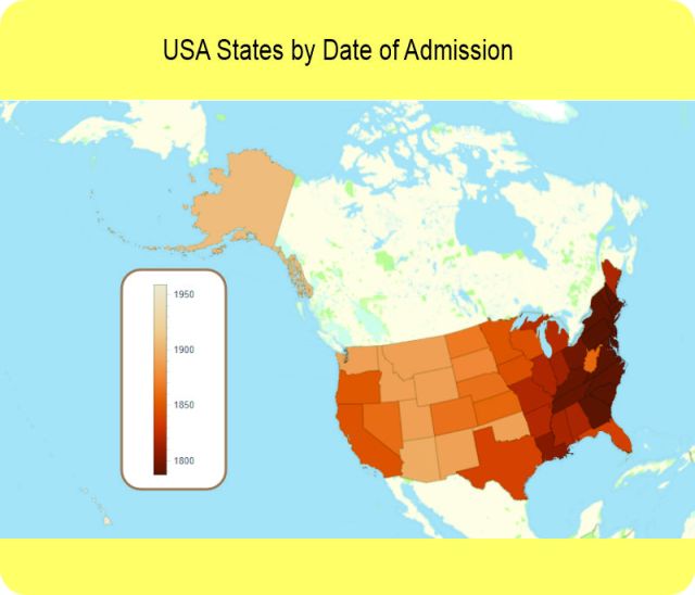
“Nice. You can almost see the country growing year‑to‑year. … Ah, Hawai’i’s in there, too, tucked away in the southwest corner. It’s color’s so pale you have to look for it. West Virginia — let me guess, right around 1860 or so, right?”
“1863. Those folks rebelled against the Southern rebellion. Anyway, Jeremy was kinda looking over our shoulder and this map lit a fire for him. You know he’s doing an Indigenous History project with Professor Begaye. He ran off and brought back a list of where each state’s name came from. We coded that up, fed it to the program and this came out.”
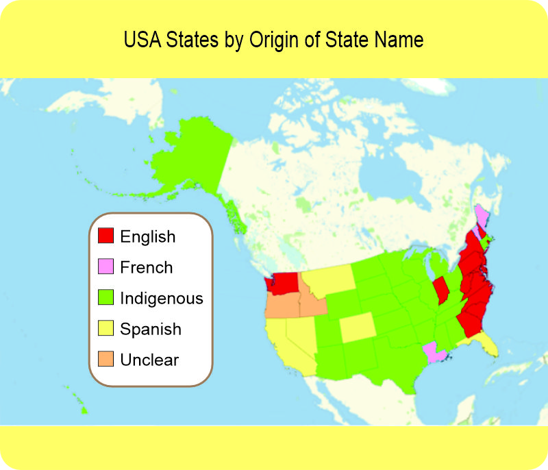
“Wow. The Europeans pretty much claimed the coasts but look at all the green. It’s like the states acknowledged they were built on Native land. Indiana comes right out and admits it.”
“Yup. Jeremy said it was pretty poor compensation. I understand how he feels.”
“So, did you map anything more than the USA?”
“Of course. Larry wanted more silly so we went with the number of letters in each country’s name.”
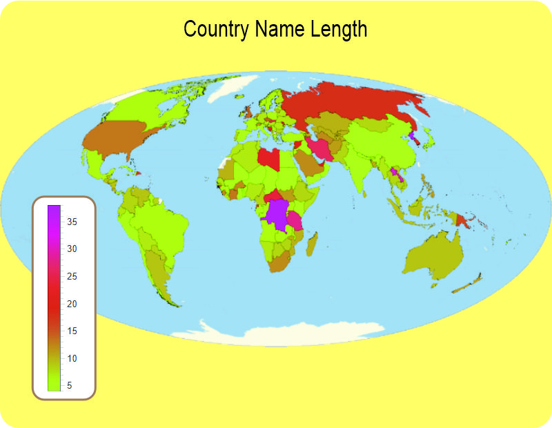
“I don’t understand this one. Peru’s green for its short name, naturally, and so are Chad and Cuba, but why are Iran and Iraq different colors? Russia’s name isn’t longer than Saudi Arabia and Madagascar. How can five‑letter Congo be purple for a really long name? Doesn’t make sense.”
“Our name list came from the International Standards Organization. Larry and me, we’re both international charter pilots. We’re often checking ISO files for radio frequencies, airport codes and the like. According to ISO, Iraq is ‘IRAQ‘, but Iran is ‘IRAN (ISLAMIC REPUBLIC OF).’ Russia is ‘RUSSIAN FEDERATION‘ which is longer than the other two. The USA would be redder if it was ‘UNITED STATES OF AMERICA,’ but it’s ‘UNITED STATES‘ and tied with ‘LIECHTENSTEIN‘ and ‘GUINEA‑BISSAU‘ at 13 characters so it’s brown.”
“And Congo?”
“The ISO name is ‘CONGO, THE DEMOCRATIC REPUBLIC OF THE.’ That’s not even the longest. It’s beat by ‘KOREA, DEMOCRATIC PEOPLE’S REPUBLIC OF‘ and ‘MACEDONIA, THE FORMER YUGOSLAV REPUBLIC OF.’ Politics, I suppose, and maybe ego. But I ain’t showed you the coolest map.”
“I’m all eyes.”
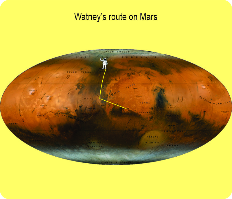
“You’ve read Andy Weir’s book, ‘The Martian‘?”
“Of course. Saw the movie, too. It was a nice change watching a drama that didn’t involve people battling each other physically or emotionally.”
“Uh. Yeah. I just saw it as an adventure story. Whatever. You remember Watney’s epic drive across that red desert to recover parts from the Pathfinder lander and then get to the launch vehicle?”
“Mm‑hm, though I don’t remember the geography.”
“Well, here’s his road map — Aries Base in Acidalia Planitia to Pathfinder in Chryse Planitia to take‑off from Schiaparelli Crater. Cool, huh?”
“Quite cool.”
~~ Rich Olcott

Interesting
1 You have entirely too much time on your hands! Happy Thanksgiving.
LikeLike