Mineral Winds

“Hey, if you guys are gonna use one of my tables at lunchtime, you oughtta order pizza.”

“Eddie, Eddie, you’re the one asking the questions that kept Kareem here into lunch hour. You owe him, seems to me.”

“Mmm, okayyy, but Sy, you can ante up. What can I get you, Kareem?”

“Nothing, thanks, unless you’ve got a halal oven.”

“Matter of fact I do, sort of. There’s a hotspot on the top left I only use for cheese melts so it should be OK for you. No pork spatters up there ever, that’s for sure.”

“A cheese melt would be fine, thanks.”

“Same for me, Eddie.”


<a few minutes later> “Here ya go, guys, straight outta the hotspot, lightly browned on top. Better let them sit a minute, you don’t wanna burn your mouth.”

“Thanks for the warning, Eddie.”

“Whatcha got there, a map?”

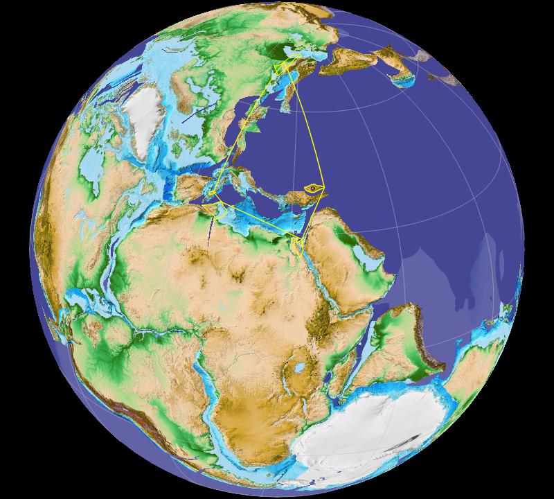
“Mm-hm, red dots for Earth’s sixty confirmed or proposed hotspots. Sy wanted to know more about the one that did a number on India.”

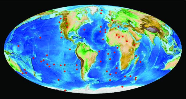
“What’s a hotspot? It’s like a big volcano, right?”

“Related but not quite. Most volcanoes are near where two plates are colliding. The classic case is the volcanoes along the western coastlines of the Americas The continents push westward and ride over Pacific seafloor plates, even break off slabs they shove down into the mantle where the heat melts them. The molten material squeezes up through cracks and escapes through volcanoes. Look where the dots are, though.”
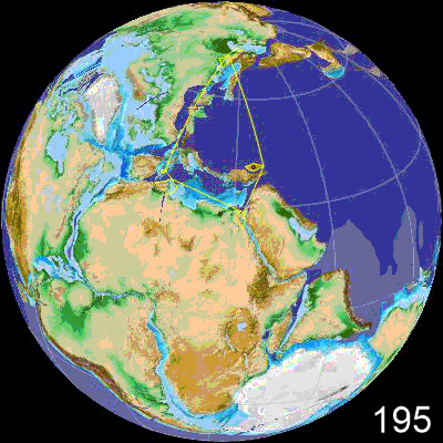
BOW Bowie  COB Cobb
HAW Hawai’i
ANA AnahimYEL Yellowstone

“Most of them aren’t anywhere near the edge of anything. Yellowstone and those guys in Africa are as far from an edge as you can get. And I don’t see any red dots near Japan or the Philippines which are both really active for volcanoes and earthquakes.”

“Right, Sy. The primary criterion for a hot spot is vulcanism far from plate edges. But there’s another characteristic that many share. It’s easiest to see in this close‑up. Start with the Hawai’i, Cobb and Bowie hotspots. Each one is at the head of a straight‑line chain of volcanoes, older to younger as you get closer to the hotspot. The chains even run parallel with each other. The Anahim and Yellowstone hotspots also have parallel chains but they go west‑to‑east which makes sense if the continents are moving westward. It all fits with the idea that hotspots have stable locations in the mantle, and they scribble volcanoes on the plates that move over them. That’s the basis for much of what we know about ocean‑plate motion. But.”

“But?”

“There’s controversy, of course. Magnetism surveys and isotope data seem to show that some hotspots may move or even flutter slowly in some geology‑timescale wind. I just read—”

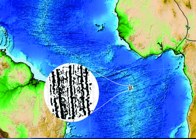
“Hey, Kareem, I’ve decorated so many pizzas with pepperoni slices I see red‑dot patterns everywhere. Your world map looks like there’s a ring of red dots around Africa and a stripe across the south Pacific. Does that mean anything?”

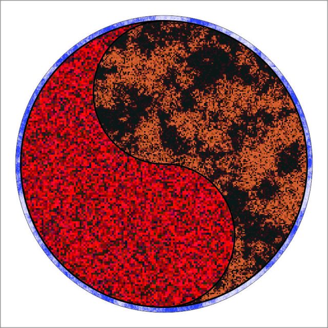
“We think it does, Eddie, but we’re still figuring out what. A technique called seismic tomography has given us evidence for a pair of huge somethings called LLSVPs deep into the mantle and on opposite sides of the Earth. One, unofficially known as TUZO, underlies much of Africa and that hotspot ring you noticed. The other one, JASON, is below your hotspot stripe in the South Pacific. We know very little about them so far, just that they stick out in the tomograms and they’ve probably been more‑or‑less where they are for a billion years. And no, we have no idea why hotspots appear around the edge of TUZO but along the center of JASON.”

“What else is lurking down there?”

“Who knows? The textbook diagrams show the mantle as this inert homogeneous shell sitting between core and crust. But its upper part is fluid and six times deeper than our atmosphere. The new tech is showing us currents something like winds and objects something like clouds, all at geological sizes and timescales. Classical Geophysics down there has been like doing weather science but ignoring clouds, mountains and oceans. There’s weather beneath us and we’re just beginning to see it.”

~~ Rich Olcott

The Bad, Sad, Rad Red Dot

“Was it just my imagination, Kareem, or was there some side action going on in that Africa‑Eurasia nutcracker video?”

“Always the trained observer, eh, Sy? You’re right, India had an interesting life in the same era. Here, let me bring up another Gplates video on Old Reliable. I need to show both sides of the world so I’ll switch from orthographic to Mollweide projection. Aannd I don’t need to go quite as far back, only to about 120 million years. Mmm, yeah, I’ll squeeze in some special markings, give me a sec… There. This slick enough for you?”

India’s 120-million-year journey
rendered using the GPlates system
and configuration data from Müller, et al., 2019, doi.org/10.1029/2018TC005462

“Busy, indeed. Care to read out what‑all is happening?”

“Sure. The big thing, of course, is the new ocean opening up around the Mid-Atlantic Rift. Further south, by 120 million years ago Gondwanaland had already calved off South America and Africa so all it had left was Madagascar, India, Australia and the Antarctic.”

“Somehow I’d always thought that Madagascar was tied to southern Africa, but I guess not.”

“Hasn’t been for 175 million years, and back then it was up level with where Kenya and Somalia are now. OK, what caught your eye east of Africa was India zoomin’ on up there three times faster than South America was drifting away from Africa. What I’ve done here, I locked the display onto Antarctica so everything’s moving relative to that even though Antarctica wandered around a bit, too. Then I marked a spot in central India, dialed back to 120 million years ago and started scanning forward by three‑million-year increments. At each step I put an orange dot over my marked spot. The dot sequence shows the subcontinent’s motion up to today. You can see it’s not a straight line and the points aren’t evenly spaced.”

“The uneven spacing and wiggly line say that India didn’t move at constant velocity.”

“Spoken like a true physicist.”

“And like any physicist who sees a velocity change I wonder about the forces that make that happen. That red dot, for instance, why did it break the pattern?”

“The red dot is special because it marks 66 million years ago. Does that date ring a bell with you?”

“Umm … Ah-hah! That was the meteor that killed off the dinosaurs, right?”

“The Chicxulub impactor had a lot to do with it, but that wasn’t the whole story. The dot is already far ahead of where it should have been considering India’s previous vector. Something happened that sped that plate along a good three million years before the meteor hit. We’re pretty sure the something was related to massive continental volcanic activity on India just south of where my dots are. The lava covered half the continent, six hundred thousand square miles. All that molten discharge undoubtedly came along with toxic gases that would have fouled the planet’s atmosphere and troubled the dinosaurs and everything else trying to breathe,”

“And what caused the volcanoes?”

“Really bad luck. There’s an active hotspot, we call it Réunion after the French island that’s on top of it at the moment. India just happened to pass right over the hotspot between 69 and 63 million years ago. The spot’s rising magma punched through the subcontinent’s bedrock, ran all over the place and maybe lubricated the passage. Then along comes the meteor when India’s only halfway across the hotspot. The asteroid doesn’t hit India but where it hits is almost as bad — just off the Mexican coast, almost exactly on the other side of the planet from where India is at the time. Imagine a massive ring of violent earthquakes sweeping around the Earth’s surface and coming to a focus smack in the middle of the volcanoes. That’s my shooting red line, except the shakers really come at India from every direction. The magma outflow rate doubles. Altogether, the discharge finally lays over 1015 metric tons of lava on top of poor India and whatever’s living there at the time.”

“Wow. Talk about your perfect storm.”

“The only good thing to come out of it is all the minerals in the magma left India with incredibly fertile soil.”

“That’s something.”

~~ Rich Olcott

Ka-RUNCH!

“Kareem, will you ever actually tell me what’s going on with the volcanoes in Italy and Greece and Turkey? And do it quick, I gotta start getting ready for the lunch trade.”

“Eddie, you’re the one who keeps asking the side questions. Sy, I see you’re carrying Old Reliable.”

“I always travel ready for action, Kareem.”

“You got the GPlates system loaded in there? It’s a go‑to tool in our Geophysics lab.”

“Matter of fact, I do, but I’ve not had time to start playing with it. Here, show us what it can do.”

“I’ve got a particular display in mind, give me a minute. <busy‑fingers pause> There. What you’re looking at is Planet Earth as we think it was 195 million years ago.”

“Is that Pangaea?”
 ”Is that Pangaea?”

“Sure is. Most of Earth’s high‑silica slag had sutured together in one big supercontinent that stretched from pole to pole.”

“What’s on Earth’s other side?”

“Mostly a huge ocean, which is why I colored it flat blue. There were probably seamounts and rifts and stuff scattered around the seabottom but all that high‑density low‑silica structure is long gone, shoved below by the continents that rode over it. This is a snapshot at the time when Pangaea was just beginning to come apart — you can see where South America is ripping away from Africa at their southern juncture, and North America’s just started to move off to the west.”

“What’s the difference between the light blue and the darker blue?”

“Good eyes, Eddie, and it’s important. The light blue is the continental shelf.”

“It’s not part of the continent?”

“Oh, it is. The shelf’s the flooded margin, partly ancient consolidated rock and partly sediments that have washed down over the ages. There’s usually a steepish drop‑off from the shelf down to the abyssal bottoms. My hero Wegener is the guy who realized that when you’re putting the jigsaw puzzle together, the shelf is the border you need to pay attention to.”

“What’s the yellow-line kite shape?”

“It ties together some points that’ll help answer Eddie’s Italy‑Greece‑Turkey question. Let me put the video in motion…”

Earth from 195 million years ago to the present
rendered using the GPlates system
and configuration data from Müller, et al., 2019, doi.org/10.1029/2018TC005462

“I see you’ve got Africa in the center instead of the usual New World axis.”

“Why not? Anyway it’s convenient for Eddie’s volcanoes. See that fragment at the kite’s eastern corner? I marked it with dark circle. Watch what happened to it about 55 million years ago, and where it went after that.”

“It banged into what’s gonna be Turkey!”

“Mm-hm, and the land crinkled up and that’s the origin of Turkey’s volcano belt that I’ve marked purple. GPlates calls that chunk the Kirsehir plate. No connection with the vulcanism further west.”

“Wait. That little thing is a plate?”

“The definition depends on who you’re talking to and what about. Officially we’ve got cratons, major plates, minor plates, microplates and terranes, but there’s fuzzy lines between them. GPlates ‘plate’ list contains about a thousand chunks that have moved around independently and are big enough to pay attention to.”

“I can see why you called it the Africa‑Eurasia nutcracker, Kareem. It crunches right down on that continental shelf north of Africa.”

“That’s the planet’s oldest bit of seafloor, Sy, maybe 300 million years old, half again older than anywhere else. Maybe the rock got brittle with age, but the collision region’s faults and folds are incredibly complex.”

“It’s a hot mess, HAW!”

“Can’t say you’re wrong, Eddie. Anyway, south and west of Turkey there’s a whole series of trenches where north‑bound seafloor crust dives under south‑bound structures. The sunken material melts, puffs up and pushes up against what’s above it. All of that leaves beaucoodles of weak spots for magma to leak upwards and you get volcanoes throughout the red‑marked area.”

“One thing I get from this, Eddie, is that it’s not one long arc from Italy through Turkey. Kareem’s pointed out two different formation periods, 50 million years apart.”

“I get that, too, Sy. It’s amazing what you can see when you look close.”

“And when hundreds of researchers gather data over two centuries.”

“Thanks, Kareem. Gotta go.”

~~ Rich Olcott

The Tale of The Stripes

“Wait, Kareem, Eurasia and Africa acting like a nutcracker? I thought Africa is moving straight east, away from the Mid‑Atlantic Ridge.”

“Uh-uh, Sy, everything seems to be swinging around eastern Turkey, Africa going northeast—”

“Africa’s moving? How does anybody know that? How does this ‘continental drift‘ even work?”

“Eddie, those are the questions that messed up Alfred Wegener’s reputation.”

<Eddie settles back in his seat> “I can see this is gonna go on for a while.”

“A little bit. Don’t go throwing shade at my man Wegener, Sy. He wrote the standard textbook in meteorology. He was honored as a pioneer in polar weather studies. He even died saving other people during a polar expedition. His book Origins of The Continents And The Oceans went through four editions so it’s not like his proposals were ignored. The old-line geologists weren’t happy because he used evidence from outside their field and besides, they didn’t believe there was a power source big enough to move continents.”

“Evidence from outside the field?!! The nerve!”

“Nuts, huh? Like, <putting up fingers> Meteorology — glacier tracks from what are now tropical areas. Paleontology — fossils of animal and plant species found on multiple continents that are far apart today. Cartography — everyone who’s seen a world map has picked up on how South America almost fits into Africa’s west coast. Wegener showed that the fit’s much better when you work with the continental shelves. Better yet, he showed how all the major land masses could fit together that way into one big supercontinent.”

“Pangaea!”
 ”Pangaea!”

“Right, except being German he called it der Urkontinent, meaning the original continent. In his day there were well‑documented geological surveys that matched layers and faults between the North American Appalachians and the Caledonian formations in Scotland and Norway. Not even those forced the geologists to buy in until oceanographers in the 1950s came up with new kinds of evidence that sealed the case. Poor Wegener was 25 years dead by then.”

<Eddie sits up in his seat> “OK, everything moves, but how do you know what direction?”

“Magnetic measurements are a prime data source. When magma exits a volcano, its magnetic atoms like iron tend to align with Earth’s magnetic field and get locked that way when the magma freezes to become lava. Measure the magnetism of a good lava field, you know which way was north at the time of eruption. If it’s a continental lava field you can even grab rocks and assay their radioisotopes to date the field. Do that with two related fields and you can work out where the mass was going at the time and how fast it was getting there.”

<Eddie sits forward in his seat> “So what’s the answer to the geologists’ biggest gripe?”

“The power source? We didn’t have a clue until those 1950s oceanographics guys started mapping magnetic fields and comparing them with improved sonar maps of the ocean bottom. We’d long known about seamounts in the middle of the Atlantic, but sonar scans revealed they’re links in a continuous 10000‑mile chain centered on a broad ridge. It’s almost a single 10000‑mile‑long volcano. Meanwhile, magnetometer scans showed a strong signal right over the chain, just as you’d expect for a lava field. What researchers didn’t expect was two parallel sets of magnetic stripes on either side of the ridge. The stripes march all the way to the coasts on either side. That explained everything, almost.”

“Not to me, it doesn’t”

“Oh, I forgot to mention that we already had evidence from continental lava fields that Earth’s magnetic field flips every half‑million years about, and no, we don’t know why that happens, that’s the ‘almost.’ Anyway, each stripe echoes the field direction at the time it froze to make fresh seafloor. Each flip starts a new pair of stripes sliding away. It all fits a model assuming that below the seafloor there’s a 10000‑mile‑long roll of rising magma in the upper mantle. The rolling pushes up to create the ridge, which cracks open at the center to create the volcanoes. Meanwhile the magma diverges to either side and pushes the Americas apart from Africa and Europe.”

“But what about Italy and Greece?”

~~ Rich Olcott

Just Floating Along

Eddie gets impatient. “OK, I get why volcanoes don’t spit metal, but why do they line up like we got across Italy, Greece and Turkey?”

Kareem gets repetitive. “Like I said, tectonics.”

“Sounds like a brand name for fancy fizzy water. What’s that really?”

“Directly it’s a reference to mountain‑building. Really it’s about everything that happens when the continents move around. That starts with light things floating on top of dense things, like a planet’s rocky material floating on the core.”

“Wait, rocks are heavy. Why should they float on anything?”

“Depends on the rock. Pumice floats on water, but it cheats because it’s loaded with bubbles. Most rocks don’t have bubbles, though. I think of them as compact silicon dioxide structures with an optional sprinkling of metal ions. A silicon atom weighs twice as much as an oxygen, but single iron and nickel atoms weigh nearly as much as an entire SiO2 unit. When everything’s all molten, like back when the proto‑planet was being pelted with millions of asteroids and stuff, atoms can move around and dense ones tend to move downward. Light atoms in the way get shoved towards the surface. Geologists call the process differentiation. Anyway, what you wind up with is a hot core of iron, nickel and other heavy atoms. The core’s surrounded by coats of lighter atoms, mostly silicon and oxygen because those were the most common atoms in the gas cloud we started with.”

“Not hydrogen?”

“Hydrogen was there originally, Sy, but many geologists think that the metal‑silicate mishmash was so hot that most hydrogen atoms shot from the mix beyond escape velocity and just sped off. Solar radiation drove them out to where the gas‑giant planets could capture them. The same geologists think the hydrogen we have now came later, as H2O from incoming comets. There’s a lot of argument on the whole issue.”

“That’s all good, Kareem, but when does the tectonics happen?”

“About 4 billion years ago, Eddie, when the asteroid bombardment tapered off. That shut down a major heat energy source so things started to cool off. Each layer cooled off at a different rate. The silica‑rich slag that rose to the surface radiated heat directly to the Universe and formed a solid crust. Meanwhile the metal‑rich layers inside stayed fluid but contracted.”

“Wait, if the inside shrinks but the outside’s a solid it’d crinkle up like a grape going raisin.”

“Absolutely, and some of us think that’s what happened with Mars and maybe Pluto. That crinkle‑up kind of mountain building is called ‘thrust tectonics.’ There’s evidence that Mars now has a ‘tight cap’ structure with a continuous crust that completely envelops the planet. Along with volcanoes and meteor craters, thrust tectonism seems to have been a major landscape driver there.”

“If there’s a tight cap, there ought to be a loose cap.”

“There is, Sy, and we’re standing on it. About 30% of Earth’s surface is continental crust, high in silica and light metals like aluminum. The other 70% is oceanic crust, which is much thinner. It’s also denser because it’s richer in heavier metals like iron. Some people like the theory that Earth once had a tight‑cap crust of continental material, but a catastrophic collision tore off most of it and gave us the Moon. Anyhow, what continental crust we have is in pieces that are loose enough to wander across the surface.”

“This is starting to sound familiar. I bet they bump into each other, right?”

“On-target, Eddie. The big pieces are called plates. The study of ‘plate tectonics‘ is about the ways they collide.”

“Wait, they got different ways to collide?”

“Oh, yes. The simple case is an equal‑density collision, like north-bound India crashing into Asia. The edges of the plates crinkle up to make mountain chains like the Himalayas. More interesting things happen in a different‑density collision. The low‑density continental crust rides up over the high‑density oceanic crust, drives it down into the hot interior where it melts and rises up, burrowing through anything above it to make—”

“Volcanoes! And my Italy‑Greece‑Turkey line—”

“Is probably the leading edge of what may be the planet’s oldest ocean crust, squeezed in by the Eurasia‑Africa nutcracker.”

~~ Rich Olcott